MIT researchers fight gridlock with Linux
Feb 2, 2008 — by Eric Brown — from the LinuxDevices Archive — 1 views At the Massachusetts Institute of Technology (MIT), researchers are testing a Linux-based automotive telematics system intended to reduce traffic congestion. CarTel is a distributed, GPS-enabled mobile sensor network that uses WiFi “opportunistically” to exploit brief windows of coverage to update a central… traffic analysis program.
digg this story |
The CarTel system is used to test a growing number of automotive-related research projects at MIT's Computer Science and Artificial Intelligence Laboratory (CSAIL). In some ways, the system is similar to the recently announced Dash Express navigation system, in that it uses embedded Linux, GPS, and WiFi, and links up to a central route analysis system. Unlike Dash, however, CarTel currently lacks a display or real-time navigation and mapping features. Dash, meanwhile, offers additional location-based services and incorporates a cellular modem (850MHz triband GSM) to provide a continuous connection, switching to WiFi when available.
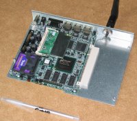
CarTel, open and with case
Some experiments using the CarTel design have used a cellular modem, says Associate Professor Sam Madden in an interview. Yet, the main goal is to find out how much can be achieved with an intermittent communications system. Cellular service would add significantly to the operating cost of the system.


CarTel leaders Sam Madden (left) and Hari Balakrishnan (right)
Madden, who leads the project along with Professor Hari Balakrishnan, says CarTel's goal is to establish a flexible, affordable platform for diverse automotive-related research projects. These include testing continuous-stream querying, exploring issues of mobile, intermittent WiFi, and researching fleet management applications, driver safety technology, and identifying pothole location for maintenance planning.
The main focus, however, is to develop sophisticated route-selection algorithms to address the problem of congested traffic. “Everyone agrees that traffic is a pain,” says Madden, “so avoiding it is good. Hopefully this will have some direct benefit to users.” Improving routing could have a significant impact on commute time, says Madden, which in turn would reduce fuel consumption and pollution.
As a test deployment, the CarTel team installed Linux-based computers and sensor kits in 30 limousines from a Cambridge, Mass.-based livery service called PlanetTran. For the last year, the hybrid-based limos have been driving around collecting data about Boston-area traffic conditions, as well as information about potholes, WiFi availability, and the health of the cars themselves.
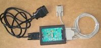 CarTel's OBD-II interface |
The CarTel computer is equipped with an OBD-II (on-board diagnostics II) interface to the car's sensor network. This lets it record speed, mileage, emissions, RPMs, and other information. In addition, the car computer hooks up to additional sensors, depending on the experiment, such as cameras or three-way accelerometers to measure and map potholes. Other possibilities include noise and pollution detectors.
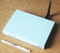
Inside CarTel
The current hardware platform for CarTel is a box about 7 x 5 x 1 inches equipped with a Soekris net4801 single-board computer (SBC) running Linux 2.6. The computer has a “586-class” CPU running at 266MHz, with 128MB of RAM, and 1GB (or more) of flash. The CarTel box is equipped with two serial ports for collecting sensor data, plus a USB 1.1 port, and a WiFi card plugged into a miniPCI slot. A commodity GPS unit is connected via one USB port. A Bluetooth dongle connects to the other USB port, allowing connections from a mobile phone. For telematics data, the system uses an OBD-to-serial adapter from ScanTool.net.
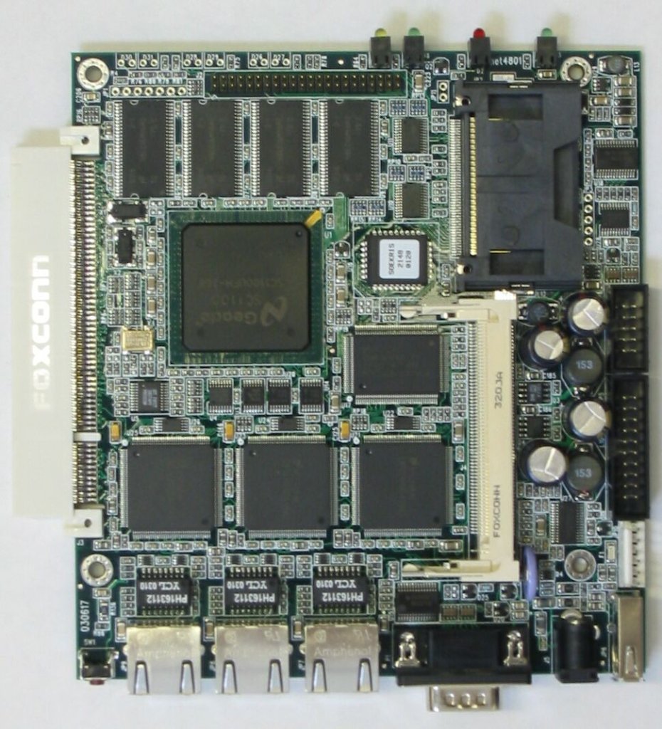
CarTel's Soekris net4801 SBC
(Click to enlarge)
The MIT team has developed some innovative technology to get the most out of fleeting, off-and-on encounters with WiFi access points. First, it has developed a WiFi communications protocol called EasyWiFi that is optimized for brief encounters. EasyWiFi takes only about a hundred milliseconds to establish a mobile wireless connection, says Madden, instead of a more typical five to ten seconds. The modifications are only on the client side, so the protocols can work with any WiFi connection.
Other communication protocols handle variable and intermittent connectivity. A “dpipe” (delay-tolerant pipe) transport programming abstraction developed by postdoc Jakob Eriksson allows producer and consumer nodes to reliably transport data across an intermittently connected network. The client-server dpipe connection is optimized for start-and-stop delivery and for situations when the IP address of an end-point changes frequently.
The dpipe uses a modified delay that can maintain its status even when the session is dropped, says Madden. “When connectivity is availability again, it pops the data out the WiFi connection to the server where it stores it in memory,” he adds.
A longer term store-and-forward technology, called CafNet, (carry and forward network) employs protocols that enable cars to serve as data mules, delivering data between nodes that are not connected via telecommunications. This technology could be used, for example, in military, mining, agricultural or scientific applications that are spread out over vast distances, delivering data from sensor networks deployed in the field to Internet servers. Each sensor would require only short-range WiFi connectivity, thereby lowering costs and easing maintenance.
Real-time queries and what-if route algorithms
Distributed sensor data is processed by a portal application that is built around a Linux- and SQL-based stream-processing query application called ICEDB. This delay-tolerant, continuous query processor enables applications running on the portal to issue queries via an API, or transfer a sequence of data between nodes using dpipe. Queries can specify what sensor data is needed and at what rate, and how the data should be sub-sampled, filtered, summarized, and prioritized.
Applications can also query the portal's relational database for analysis. These “snapshot” queries work from available data and don't need to wait synchronously for complete results. All this underlying complexity is shielded from the developer, says Madden, so it appears like a standard SQL relational database.
The ICEDB database was modified from a similar “TinyDB” database that Madden developed years ago for the TinyOS operating system. TinyDB was used to query continuous-feed data from sensor networks that used sensor motes from Crossbow Technologies.
“We made a conscious decision to move to Linux because TinyOS was not as easy to work with,” says Madden. “With Linux, there are also a huge number of people developing device drivers, and our graduate students already know how to develop with it.”
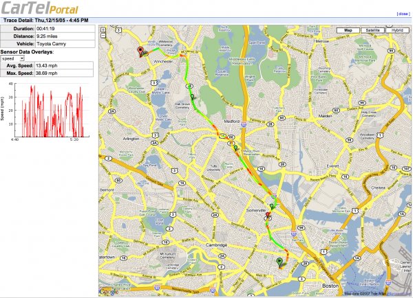
CarTel portal showing congested routes ranging from red (slow) to green (average)
(Click to enlarge)
The CarTel portal provides a geo-spatial data visualization system based on Google Maps that stores and marks sensor data using GPS coordinates. The portal organizes data as “traces,” linear sets of sensor readings collected during a drive. Users can query the system using a graphical query interface to select traces, and then visualize the traces combined with various summaries, statistics, and maps. The portal allows queries both on the driver's own history, as well as the aggregate driving history of other drivers.
Users could include fleet directors, city planning officials, or the drivers themselves, logging in either from a WiFi-enabled laptop in the car or later at home. For example, drivers can see congested areas of their commutes marked in red, orange, and yellow segments, with greens indicating average speeds, and the rare blues indicating clear sailing.
The current focus of the project is in developing algorithms that run on top of the portal application to help drivers plot the best route at a given time. For example, the team's MyRoute project includes applications that model delays observed on road segments as statistical distributions. Various algorithms then use these to compute optimal routes for different times of the day.
“Instead of asking the shortest time or shortest distance from point A to point B, you ask what route should be taken, say, for the highest probability of getting to the airport by a certain time depending on the time selected,” says Madden.
Meanwhile, additional research is underway using CarTel to improve fleet management and fine-tune street repair schedules based on identifying the deepest potholes that cars are hitting most frequently. Other research will investigate using telematics data to warn drivers of potential safety hazards or maintenance needs.
With the Soekris net4801 expected to reach end-of-life later this year, the CarTel group is planning to move to another Linux-based design, hoping to reduce the current over-$400 pricetag for the complete system. The plan is to expand the network to 1,000 vehicles, which will help improve the granularity of collected data for better route planning. Other potential lines of inquiry include peer-to-peer WiFi communications between cars to sense upcoming traffic congestion or to assist in onboard safety systems.
Last May, a U.S. government- and industry-led coalition called the Vehicle Infrastructure Integration Consortium (VII-C) was established, aiming to equip every car and roadside in America over the next decade with wirelessly connected Linux-based computers. The goal is to lower driver death rates, reduce traffic jams, and media-enable cars before 2017. The VII-C is funded by the U.S. Department of Transportation (DOT), and includes seven vehicle manufacturers already involved in the U.S. DOT's Intelligent Vehicle Initiative.
More information on the MIT CarTel project can be found here.
–by Eric Brown
This article was originally published on LinuxDevices.com and has been donated to the open source community by QuinStreet Inc. Please visit LinuxToday.com for up-to-date news and articles about Linux and open source.